
The earth's crust beneath the Pacific Ocean with its underwater mountain ranges and deep trenches has been the subject of various scientific theories of plate tectonics. A new theory involves the subduction of an oceanic mountain ridge beneath the continental plate of Asia, with Japan acting as a stopper preventing further subduction and maintaining stability. The cause and extent of the submergence is still a mystery to oceanographic scientists and the effects they conjecture are a long way from fact, This geological event is believed to have occurred some 50 million years ago. (See link to extract from article below)
Oahspe has given an account of the geological nature of the Pacific Ocean and the now submerged continent of Pan. This means that in 1882, Oahspe provided knowledge of the geological history of the earth's crust which was not a part of any corporeal knowledge existent on the earth at the time. Any references to the existence of a continent in the Pacific, such as Mu, did not appear until decades after the publication of Oahspe. The breaking of the crust of the earth around the ancient continent has been described in Oahspe as being accomplished by etherean Gods and Goddesses around 25,000 years ago. But the ocean floor of the Pacific offers many clues to the extent of the submerged land. Apart from the deep trenches along the northern and western borders, the deep trench to the south (north of New Zealand) called the Tonga/Kermadec trench begins a series of `Fracture Zones' (Udintzev, Eltonin, Challenger, Clipperton, Clarion, Molokai, Murray, Mendacino,) that stripe the South Eastern and North Eastern Pacific in a wide arc. This arc follows the Eastern contour of the outline of Pan as shown in Oahspe and ends in the Aleutian Trench in the far North. The fracture zones (Udintzev and Eltonin) that run along the long eastern rise toward the West coast of South America differ in length and distance from each other compared to the more frequent fracture zones of the `North Eastern Pacific Basin' between the ancient eastern coastline of Pan and the West coast of North America. These coasts were relatively close and would account for the fracture zones being so close together and more frequent along the whole length, indicating the kind of dislocation required to allow the submergence of the land on one side with the land on the other side remaining intact. (See link to Map below). Oahspe: Bk of Aph, Chapter 3.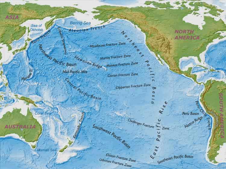
The ocean floor maps outline mountain ranges that co-relate to the map of Pan in Oahspe (Plate 59, pge 606 [1882]).
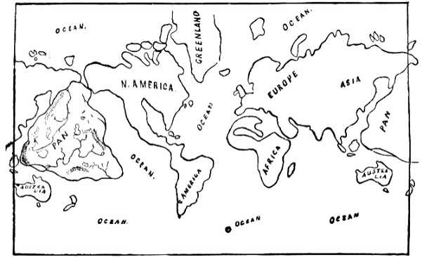
The Oahspe map of Pan defines two long rivers, their source and direction of flow appear to be from the highlands to the sea. The western river begins at the foothills of the arc of the South Western range and fed by a major tributary from the North Western range more than half way along, leading to the sea in the area of 170.N and 60.E. Along the course of the river there is a large circular lake east of the mountains whose remnants are above sea-level and are known as the islands in the vicinity of Taiwan (including the famous undersea ruins near Okinawa). The almost perfect circle of this lake is apparent in that position on the ocean floor map at 13 E and 155 N. A smaller lake to the North West of the course of the river corresponds to the large low region known as the `Northern Pacific Basin' on the ocean floor map.
The South Eastern River appears to flow from a number of smaller rivers that spring from the foothills along the western side of the Eastern Highlands which now exist as the Hawaiian Ridge, and reaches a large delta area that appears to run into the sea in what is now the vicinity of the Bismarck Arch which is just east of the North Eastern coast of New Guinea. The are various lakes which feed into the tributaries, before joining to flow to the south West, this large lowland area can be seen on the ocean floor maps as the `Central Pacific Basin' Rivers have their beginnings in mountainous regions, and these mapped in the Oahspe map of Pan are clearly seen to correspond with the undersea mountain ridges of modern ocean floor maps. The Lakes in lowland areas of the map of Pan, correspond with low areas between undersea mountainous areas on the ocean floor maps. These areas were not mapped to any extent before 1977, and even then it required the development of technology such as electro magnetic, sonar and satellite imaging to further define the details now available. Here is confirmation that Oahspe's map of Pan contained information that would not be mapped as the topography of the ocean floor until more than a hundred years afterward.